The River Baetis

From the beginning of time, Corduba chose its location according to the river. The objective was to control the seasonal fords, which permitted the connection between worlds almost antagonistic. At the same time, it allowed the output of metals from Sierra Morena and the agricultural products from the countryside through its waters, as the river was navigable to its very gates.

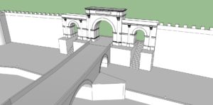
The first documented references to the existence of a bridge go back to the year 45 BC, during the siege of the city by the troops of Julius Caesar in their civil wars against Pompey’s sons. This first bridge should have been mainly constructed with wood materials. In imperial times, with the first ordination of the Via Augusta (at the beginnings of the 1st century AD), it would have been replaced by a stone one, basis of the current.

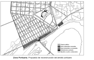
The city was also provided with a great port that turned the river into fundamental link of goods and people across the Mediterranean. We barely have archaeological evidence of it, but we know it had a large stone reef on the right bank of the river.
This port area would have had the entire necessary infrastructure for its proper management and operation, and would have employed wide shallow draft vessels for river transport. Its economic importance was strengthened by the existence of numerous industrial, storage and trade facilities that were distributed on both sides of the bridge, forming a large harbor district at the southern end of the Roman city.

The port of Corduba lose much of its importance in the late 3rd century, when its navigability started to be reduced, and Hispalis began to gain relevance.
Bibliography
CARRASCO, I., MURILLO, J. F., RODERO, S., GONZÁLEZ, M., GARRIGUET, J. A., (2003): “Informe-memoria de la I.A.U. en el Paseo de la Ribera (1999-2001). I. sector de la Puerta del Puente”, Anuario Arqueológico de Andalucía (2000), Tomo III, Urgencias, vol. 1, Sevilla, pp. 283-298.
CASAL GARCÍA, M. T. y SALINAS PLEGUEZUELO, E., (2009): “Informe-memoria de la I.A.U. en la Puerta del Puente y en la parcela catastral 36394/09, Anuario Arqueológico de Andalucía (2004), vol. III Urgencias, Sevilla, pp. 711-722.
LEÓN MUÑOZ, A.; LEÓN PASTOR, E.; MURILLO REDONDO, J. F. (2008): “El Guadalquivir y las fortificaciones urbanas de Córdoba”,Las fortificaciones y el mar, Alcalá de Guadaira, pp. 261-290.
LEÓN PASTOR, E. (2009-2010): “Portus Cordubensis”, Anejos de Anales de Arqueología Cordobesa, nº 2, Córdoba, pp. 45-72.
MELCHOR GIL, E. (2002): “La navegación por el Guadalquivir en época Antigua y Medieval”, en Patrimonio Histórico Hidráulico de la Cuenca del Guadalquivir, Madrid, 2002, pp. 319-347
MELCHOR GIL, E. (2008-2009): “El Baetis y la organización viaria del sur peninsular: la interconexión de las redes de transporte fluvial y terrestre en la Bética romana”, Anas, 21-22, pp. 163-191.
MURILLO REDONDO, J.F.; CASAL GARCÍA, Mª.T. (2003): Informe de la Supervisión Arqueológica de los sondeos geotécnicos efectuados en el Puente romano. Informe de la Delegación Provincial de Cultura de la Junta de Andalucía, Córdoba (Inédito).
PARODI ÁLVAREZ, M. J. (1999): El Baetis-Guadalquivir, puerta de Hispania: actas del I Ciclo de Estudios sobre Sanlúcar, Cádiz.
SILLIERES, P. (1993): “El puente grande de Córdoba” Actas del I Coloquio de Historia Antigua de Andalucía. Tomo II, Córdoba, pp. 137-141.
VAQUERIZO GIL, D. (2003): Guía Arqueológica de Córdoba, Córdoba.
VAQUERIZO GIL, D. (2008): “Ad ripam Baetis: Corduba/Colonia Patricia, simulacrum Romae”, en J. Rubiales Torrejón (Ed.), El Río Guadalquivir, Sevilla, pp. 185-195.
VAQUERIZO GIL, D. (2015): “Agricultura y comercio. Trigo, vino, aceite y garum en la Bética”, Andalucía en la Historia, 50, pp. 28-29.

